
GMDSS Radio Communications // Life-Saving Appliances
What is an EPIRB (Emergency Position Indicating Radio Beacon): Cospas-Sarsat, AIS Integration, Testing & SOLAS Rules
A comprehensive technical guide to marine Emergency Position Indicating Radio Beacons (EPIRB): operating principles across the 406 MHz digital satellite and 121.5 MHz homing frequencies, modern AIS-EPIRBs with Return Link Service (RLS), hydrostatic release units (HRU), monthly testing protocols, and false alert cancellation procedures.
An EPIRB is an autonomous, buoyant, battery-powered radio transmitter enclosed within a waterproof housing, designed to transmit distress signals to the international Cospas-Sarsat satellite constellation. It notifies Rescue Coordination Centers (RCC / MRCC) worldwide, initiating a rapid SAR response for surviving craft or personnel in distress.

1. Transmitter Frequencies and the Cospas-Sarsat Space Segment
Modern marine EPIRBs house several internal transmitters, each performing a specialized operational function:
| Transmitter / Frequency | Power Output | Operational Role in SAR Missions |
|---|---|---|
| 406.0 – 406.1 MHz (Digital) | 5 Watts (burst pulse) | Primary satellite link transmitting encoded data to Cospas-Sarsat: 15-digit Hex ID (UIN), flag country code, and internal GNSS coordinates. |
| 121.5 MHz (Analog Homing) | 25 – 50 mW | Short-range homing beacon for SAR aircraft, helicopters, and lifeboats equipped with VHF Direction Finders (VHF/DF). Satellite processing of 121.5 MHz ceased on February 1, 2009. |
| AIS (161.975 & 162.025 MHz) | 1 Watt | Mandatory under IMO Res. MSC.471(101). Transmits AIS distress messages directly to ECDIS and radar displays of nearby shipping within a 4–8 nautical mile radius. |
| Internal GNSS Receiver | Passive | Acquires GPS, Galileo, and GLONASS positions, reducing location error from several miles to under 50 meters and encoding it into the 406 MHz burst. |
• LEOSAR (Low Earth Orbit): Altitudes of 850–1,000 km. Capable of computing beacon locations using Doppler shift principles even without GPS data, but subject to pass delays of 45 to 90 minutes;
• GEOSAR (Geostationary Orbit): Fixed 36,000 km over the equator. Delivers near-instantaneous alerts globally (except polar areas beyond 75° N/S) but cannot calculate Doppler positions—relying entirely on GPS coordinates encoded in the beacon’s message;
• MEOSAR (Medium Earth Orbit): Carried aboard Galileo, GPS, and GLONASS satellites (approx. 20,000 km altitude). MEOSAR provides near-instantaneous detection (within 5 minutes) across the globe and supports the Return Link Service (RLS), sending an acknowledgment signal back to the EPIRB to illuminate a confirmation blue LED.
2. EPIRB Categories and Float-Free Operation
Maritime safety regulations categorize EPIRB carriage into two mounting arrangements:
- Category 1 (Float-Free): Mandatory for all commercial vessels under SOLAS. The beacon is secured in an external bracket equipped with a Hydrostatic Release Unit (HRU). It releases and activates automatically if the ship sinks, or can be carried manually to survival craft;
- Category 2 (Manual Activation): Stowed inside a cabin or wheelhouse bracket and activated strictly by hand. Permitted primarily on recreational vessels and small inshore craft not subject to mandatory float-free carriage.

- As the vessel submerges to a depth of 1.5 to 4.0 meters, ambient water pressure acts upon the internal diaphragm of the HRU (e.g., Hammar H20);
- A spring-loaded blade severs the plastic retaining bolt or release rod holding the housing cover;
- The buoyant EPIRB ejects from the bracket and floats clear of the sinking superstructure to the sea surface;
- Submersion bridges the external sea contacts on the casing, triggering automatic transmission on 406 MHz, 121.5 MHz, and AIS, while activating the visual strobe light (minimum 20–30 flashes per minute).
The coiled buoyant lanyard attached to the EPIRB body is designed solely to secure the beacon to a life raft or lifeboat in the water! Never tie or lash this lanyard to the ship’s rails or mounting bracket. If tied to the ship, the buoyant beacon will be dragged underwater as the vessel sinks.
3. Unique Identifier Number (UIN / Hex ID) & Registration
During factory programming or shore commissioning, every beacon receives a distinct 15-character hexadecimal code known as the Unique Identifier Number (UIN) or Hex ID. Printed permanently on the external label, this code embeds critical statutory data:
- Maritime Identification Digits (MID) indicating the vessel’s flag state;
- Vessel identification data (official IMO number, MMSI, or radio call sign);
- Serial number of the specific beacon on board.
International law mandates compulsory registration of every EPIRB in its corresponding national beacon database (e.g., NOAA Beacon Registration in the US, MCA in the UK). When a distress burst is received, rescue coordinators instantly access vessel particulars, primary shore emergency contacts (DPA), and survival equipment details. Unregistered beacons substantially delay SAR deployments.
4. Inspection Regimes and Monthly Self-Test Procedures
The operational readiness of the EPIRB must be verified under standard shipboard maintenance routines:
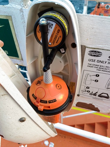
- Without removing the beacon from its bracket (unless specified by the maker), actuate the spring-loaded switch to the “TEST” position for 2 to 3 seconds, then release;
- Internal diagnostic routines evaluate battery cell voltage under load, output power on 406 MHz and 121.5 MHz, and frequency stability;
- A successful test is indicated by specified LED sequences and a strobe flash (confirm with maker’s manual);
- Record the date, time, and test result in the GMDSS Radio Log.
| Inspection Interval | Responsible Party | Statutory Scope and Reference Standard |
|---|---|---|
| Monthly | Shipboard Safety Officer | Visual inspection, check of HRU expiry date, security of bracket, and routine Self-Test. |
| Annually | Approved Radio Service Engineer | Radio survey using calibrated EPIRB test sets (measuring transmission power, 406 MHz frequency deviation, Hex ID) pursuant to IMO MSC.1/Circ.1040. |
| Every 2 Years | Vessel Crew / Service Station | Replacement of the Hydrostatic Release Unit (HRU) with expiration date marked permanently on the new unit. |
| Every 4–5 Years (SBM) | Shore-Based Maintenance Provider | Complete Shore-Based Maintenance under IMO MSC/Circ.1039: battery pack renewal, case seal replacement, and pressure-chamber hydrostatic testing. |
5. False Alert Cancellation Protocol
Accidental activation during deck washing with high-pressure hoses or during battery handling remains a frequent operational error.
If an EPIRB is activated inadvertently, never simply switch it off and stow it away. Search and rescue centers have already logged the transmission and may be launching rescue aircraft.
1. Immediately deactivate the unit (switch to OFF or dry the sea contacts completely);
2. Contact the nearest Maritime Rescue Coordination Center (MRCC) or coastal radio station via VHF Channel 16, MF/HF, or Inmarsat/Iridium;
3. Transmit the standard cancellation message:
“ALL STATIONS, ALL STATIONS, ALL STATIONS. THIS IS MOTOR VESSEL [Ship Name], CALL SIGN [Call Sign], MMSI [Number], HEX ID [15-digit code]. CANCEL FALSE DISTRESS ALERT TRANSMITTED BY EPIRB ON 406 MHZ AT [Time UTC], DATE [Date]. MASTER [Name], DATE/TIME.”;
4. Make a full descriptive entry in both the Deck Log Book and GMDSS Radio Log.
6. Comparative Overview: EPIRB, PLB, and SART
| Technical Parameter | Marine EPIRB | Personal Locator Beacon (PLB) | Radar SART (Search & Rescue Transponder) |
|---|---|---|---|
| Registration | Assigned to the vessel (linked to IMO/MMSI). | Registered to an individual person. | Assigned to a specific survival craft. |
| Operating Link | Cospas-Sarsat 406 MHz + 121.5 MHz + AIS. | Cospas-Sarsat 406 MHz + 121.5 MHz. | None. Interrogated by 9 GHz marine X-band radars. |
| Activation | Automatic (HRU/water contacts) and manual. | Manual only. | Manual (activated upon entering life raft). |
| Operating Life | Minimum 48 hours at −20°C. | Minimum 24 hours at −20°C. | 96 hours standby + 8 hours active transmission. |
| SAR Indication | Coordinates transmitted to MRCC worldwide. | Coordinates transmitted to MRCC worldwide. | Displays 12 blips/arcs on radar displays of vessels within 5–10 NM. |
Frequently Asked Questions: Marine EPIRBs (FAQ)